
Ode to Oceanography: An Antique Nautical Map Of The Northern Caribbean, Windward Islands, & Jamaica
- The Persaud Foundation

- Jun 15, 2025
- 3 min read
Today’s map in the Ode to Oceanography series is a gorgeous, nearly century-old map of the Caribbean by mapmaker J. W. Norie. This chart covers the entirety of the northern Windward Isles, Haiti, the Dominican Republic, and parts of Cuba. It covers a very large part of the Gulf of Mexico and its surrounding areas, covering approximately 64,395 square miles (166,782 square kilometers).
The map is in extraordinary condition, with every line as clear & crisp as the day that it was made. It includes a tremendous amount of information, both oceanic & topographic. It is approximately 37 inches from top to bottom, & 49 inches from side to side.
In today’s article, we will discuss the map itself, & analyze this antique nautical map. With that being said, let us delve into the exquisite Windward Isles!

The Map Itself
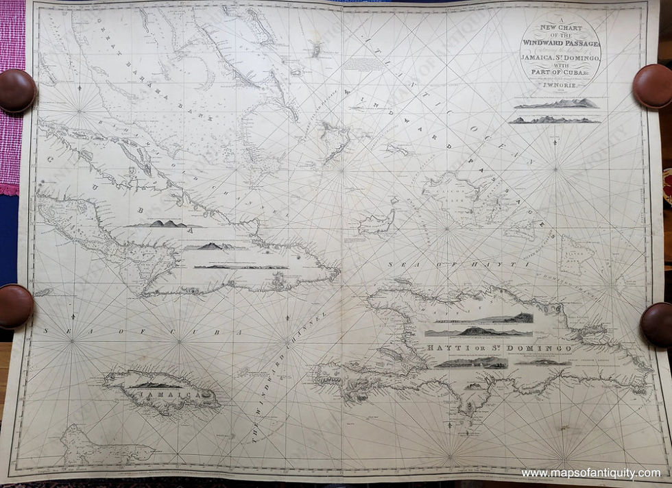
As mentioned above, this chart includes a tremendous amount of information. This chart includes all coastlines in high definition, along with water depths, & eleven compass roses littered around the map. Not only this, however it includes semi-detailed topographic information in addition to the highly detailed oceanic information. It is incredibly accurate, & near-flawless, with no blemishes or discolouration except one blotch towards the center.
An Analysis Of The Map
This chart was designed & illustrated in 1836 by John William Norie, a highly esteemed British Hydrographer & Cartographer of the 19th Century. He is most famous for his works “Epitome of Practical Navigation”, & “A Complete Set of Nautical Tables”. The map was likely made in London, in his primary cartographic office. After it came into possession of Maps of Antiquity, it was re-backed with blue paper, & restored to its full condition.
The map is incredibly accurate for its time, although the spelling of Haiti has changed, the topographic features may have changed, & the coastlines are far more developed. The chart was made for civilian sailors use, & was not intended to be used in strategic comba, or by the British Navy.
As the map was produced in 1836, it was likely made using Lithography. Lithography is a method of printing that arose in the 1820s, & remained the most popular method of printing in both color & grayscale until the early 1930s, when more efficient methods became available.
In the lithographic method, the artist will draw directly onto a printing surface, such as zinc or copper, until they are satisfied with the drawing. After this, the surface will be covered with a chemical etch, which will bond it to the surface. With this process, the blank areas will attract moisture to the plate & repel the lithographic ink, while the areas that are drawn on will hold the ink. Water is then wiped onto the unpainted areas to help prevent the ink from deviating. After the map is inked, the paper is laid over it & covered with a tympan, & the tympan is pressed down. Finally, these materials pass through the scraper bar of the litho press. Afterward, an exact copy of whatever was supposed to be printed is revealed.
Directories / Credits
All credit for this map analyzed today goes to Maps Of Antiquity, a wonderful New England map shop. To purchase this map, any other maps, or any other cartographic objects, please visit mapsofantiquity.com. To be clear, this is not an advertisement for Maps of Antiquity, as we do not have a partnership with them.
Strategic Partnerships
Reel Guppy Outdoors
SharkedSkooler
Marine Enthusiasts Podcast
Cash Daniels
Tides of Tomorrow
Our Loyal Patrons
P. R. Ochoa


Comments